
Sub-Total: R0.00


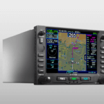
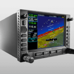
IFD545 FMS/GPS/COM/NAV
R416,754.90 excl. Vat
This is an installation only product and will not be shipped. Please contact us for a free installed quote.
5 to 10 Days Delivery
Description
Fully Featured Premium IFD: Avidyne IFD545
Avidyne is known in aviation circles for our innovative products and it’s no secret that safety and ease of use are true hallmarks of all Avidyne products. With the new top-of-the line IFD545 FMS/GPS, Avidyne combines our latest in Hybrid Touch, WAAS/SBAS/GPS navigation and communication along with stunning 3D synthetic vision technology to deliver the most powerful and capable touchscreen, panel-mounted navigator ever made.
Everything you could want and need in a true FMS
Just like the IFD440 and IFD540, the IFD545 delivers the features and functionality that makes the IFD Series popular with many pilots. Key features such as touchscreen with knobs and buttons, Page & Tab user interface, GeoFill, automatic waypoint nomination, and easy airway flight planning.
The IFD545 boasts is a 5.7” diagonal display with full VGA and 65,535 colors. Functional when flying in ultra bright sunlight, the LED backlighting makes the IFD545 display visible in any environmental condition.
The IFD545: Key Features
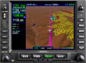
Attitude Reference System (ARS) and Dynamic SVS
Requiring no additional boxes or wiring, the IFD550 displays a three-dimensional scene representing “egocentric” (out-the-window) and “exocentric” (in trail) views of your aircraft in relation to nearby terrain and traffic.
3D Terrain and FLTA
Terrain Awareness (SVS-TA) is provided via hashed coloration of terrain. Textual and aural alerts are provided for terrain hazards. Forward Looking Terrain Alerting (FLTA) provides an extra measure of safety by displaying a solid yellow or red impact point based on projected flight path in the event that a collision with terrain is projected. FLTA also provides visual CAS messaging & aural alerting.
Airport Flags
Airfields are depicted with a METAR-style flag when in field of view. With valid METAR data from your datalink, airfield flags will be color-coded to represent the ceiling and visibility, consistent with the moving map presentation.
3D Traffic and Obstacles
The IFD550 uses standard traffic symbology to indicate threat level by target size and relative altitude and bearing. Standard high, low and grouping symbology is used to clearly depict obstacles with color-coded threat bubbles based on hazard level.
At the heart of the IFD550’s synthetic vision system, is Avidyne’s fully-integrated, NextGen MEMS- Gyro ARS sensor that senses pitch and roll.
The IFD545
The IFD545 has all the same FMS/GPS functionalities as the IFD550 but without VHF navigation and communication. The IFD545 features ARS and Dynamic SVS, including WiFi/Bluetooth®, FLTA and more.
The convenience of direct replacement

The Avidyne IFD545 is a direct replacement for the GPS 500. As a direct replacement you can get a best in class FMS/GPS for less in installation costs and downtime.
Specifications
Display (IFD550/540/545/510)
- 5.7” Diagonal w/Touch Screen
- Full VGA – 640 x 480 pixels
- 65,535 colors
- Ultrabright sunlight readable w/LED Backlighting
Dimensions (IFD550/540/545/510)
- Width: 6.30” (16.0cm)
- Height: 4.60“ (11.7cm)
- Depth: 11.00“(27.5cm) behind panel including connector
Weight (including tray and connectors)
- IFD440 – 6.88 lb (2.34 kg)
- IFD410 – 5.16 lb (3.99 kg)
- IFD550 – 9.19 lb (4.17 kg)
- IFD540 – 8.79 lb (3.99 kg)
- IFD545 – 7.48 lb (3.39 kg)
- IFD510 – 7.13 lb (3.23 kg)
Power Requirements
- 11 – 33VDC
- 4.4A/6.5A Xmit @ 14vdc
- 2.2A/4.0A Xmit @ 28vdc
VHF COM Power Output
- 10 Watts nominal
- Optional 16Watt (for 28vdc installations only)
Environmental
- DO 160E
- To 50,000 Ft
- -20C to +55C Operating
- +70C Short Term
Applicable TSOs
- TSO-C34e – ILS Glide Slope Receiving Equipment Operating within the Radio Frequency Range of 328.6-335.4 Megahertz (MHz)
- TSO-C36e – Airborne ILS Localizer Receiving Equipment Operating within the Radio Frequency Range of 108-112 Megahertz (MHz)
- TSO-C40c – VOR Receiving Equipment Operating within the Radio Frequency Range of 108-117.95 Megahertz (MHz)
- TSO-C44c – Fuel Flowmeters
- TSO-C110a – Airborne Passive Thunderstorm Detection Equipment
- TSO-C112e – Air Traffic Control Radar Beacon System/Mode Select (ATCRBS/Mode S) Airborne Equipment
- TSO-C113a – Airborne Multipurpose Electronic Display
- TSO-C118 – Traffic Alert and Collision Avoidance System (TCAS) Airborne Equipment, TCAS I
- TSO-C128a – Devices that Prevent Blocked Channels Used in Two-Way Radio Communications Due to Unintentional Transmissions
- TSO-C146d – Stand-Alone Airborne Navigation Equipment Using the Global Positioning System (GPS) Augmented by the Wide Area Augmentation System (WAAS).Airborne Supplemental Navigation Equipment Using the Global Positioning System (GPS) – Gamma 3
- TSO-C147 – Traffic Advisory System (TAS) Airborne Equipment – Class A (Display Functions Only)
- TSO-C157a – Aircraft Flight Information Services – Broadcast (FIS-B) Datalink Systems and Equipment
- TSO-C165 – Electronic Map Display Equipment for Graphical Depiction of Aircraft Position
- TSO-C169a – VHF Radio Communications Transceiver Equipment Operating Within The Radio Frequency Range 117.975 To 137.000 Megahertz – Class C, E, 3 and 5
Compatability
Satellite Datalink Weather Interface
- Avidyne MLB700/WSI AV-300 Broadcast Datalink Receiver
- GDL69/A XM Broadcast Datalink using Baron Wx Services and XM® Satellite Receiver
Electronic Approach Charts & Airport Diagrams (IFD 5-Series Only)
- CMax™ – Jeppesen Electronic Airway Manual Charts
- European VFR (Bottlang) Charts – optional
Charts, Nav Data, and other software updates are easily field loadable via USB port.
Lightning Interface
- Avidyne TWX670 Tactical Lightning Detection
- L3 WX-500 Stormscope® Weather Mapping Sensor
Wx Radar Systems
- Bendix/King RDR2000
5-Series IFDs provide integrated control and display of your on-board Wx Radar on a dedicated page or overlayed right on the map (optional).
Traffic Interface
- Avidyne SkyTrax600/605/610/615/620/A TAS/AXP322 TIS
- Ryan 9900B/BX TAS
- Honeywell KTA870/KMH880 TAS/IHAS/CAS66A TCAS I
- L3 Skywatch 497 / HP TAS/ 791 TCAS I
- Garmin GTS800/820 TAS/GTS850 TCAS I/ GTX330 TIS
ADS-B Interface
- Avidyne SkyTrax605A/SkyTrax615A/ SkyTrax620A (Traffic)
- Avidyne SkyTrax100B
- Avidyne AXP340, AXP322
- L3 NGT-9000
- Freeflight RANGR
- Garmin GTX330ES, GTX335, GTX345
Terrain Awareness
- Color-Contoured Terrain Base Map Built in
- Americas Terrain & US Obstacle Data
- International Terrain Data (optional)
Video Interface
- RS170 (optional)
IFD5-Series features an optional RS170 video input, capable of displaying video from aircraft-mounted IR/EVS or other compatible sources.
406 ELT Interface
- Aviation RS-232
- NMEA 0183
Applicable TSOs
- TSO-C34e, TSO-C36e, TSO-C40c, TSO-C44c, TSO-C110a, TSO-C112e, TSO-C113a, TSO-C118, TSO-C128a, TSO-C146d, TSO-C147, TSO-C157a, TSO-C165, TSO-C169a
Air Data
- B&D 2600, 2601, 2800, 900004-03 ADC
- Bendix King KAD 280/480 ADC, KDC 281/481
- Shadin (ADC 2000, 200, 200+), (8800T, 9000T, 9200T Alt Computer), 9628XX-X Fuel/Air Computer
- Insight TAS 1000 ADC
- Icarus Instrument 3000
- Sandia SAC7-35
- Garmin GDC74A
Encoding Altimeter or Blind Encoders
- Bendix King KEA-130A, KEA-346
- Terra AT-3000
- Sandia SAE5-35
- Trans-Cal Industries IA-RS232-X, SSD120
- ACK Technologies A-30
EFIS
- Avidyne EXP5000
- Bendix King EFS 40/50
- Collins Proline 21 EFIS, EFIS 84(non-WAAS only)
- Honeywell Primus 1000
- Sextant SMD 45
- Aspen EFD1000 Pilot PFD
Displays
- Garmin GDU 620, MX20, MX200, GPSMAP 195/295, GPSIII Pilot, GPSMAP196/296/396/496/695/696, Aera 796/795
- Argus 3000, 5000, 7000
- Horizon DDMP
- Avidyne EX500, EX600, EX5000, FlightMax Series
- BFG Stormscope Series II
Heading
- Bendix King KAH 460 Inertial System (KUA 461 also)
- Collins AHC 85 Inertial Systems Laserref
- Honeywell HG 1075AB, HG 1095AG Inertial Systems
- Litef LTR 81 Inertial System
- Litton LTN 90-100, LTN 91, LTN 92 Inertial System
EHSI
- Sandel SN3308, SN3500
Fuel
- Shadin 91053XP, 91053XT-D Digital Fuel Mgmt System “Digiflo-L”, 91204XT (38) D, 91204XT-D Digital Fuel Mgmt System “Miniflo-L”, 91802-() “Digi Data”
- JPI EDM-700/760 Engine Monitor, FS-450
- ARNAV FC-10, FT-10
- EI FP-5l
- Insight GEM 3
Traffic
- L3 SKY497 SkyWatch, Sky899 SkyWatch HP
- Bendix King KTA-870/970, KMH980/880
- Garmin GTS 800/820/850
- Ryan TCAD 9900B/9900BX
- Avidyne SkyTrax 600/605/610/615/620
Transponder
- Garmin GTX 330/330 ES/330D ES/327
- Avidyne AXP340
- Trig TT31
Lightning
- L3 WX500
- Avidyne TWX670 “Native” Format
Datalink
- Garmin GDL-69/69A
- Avidyne MLB700
- WSI AV-300/350
Autopilot
- Avidyne DFC90
- Bendix King KFC400/325/320/300/275/250/225/200/150, KAP150/140/100
- Century I/II/III/IV, 21, 31/41, 2000, Triden, AK 1081 GPSS Converter
- Collins APC-65 Series, FGC-65, FYD-65
- STec 20/30/40/50/55, 55x, 60 PSS, 60-1, 60-2, 65, ST901 GPSS Converter
Misc
- Garmin GAD42 Interface Adapter
EGPWS
- Bendix King KGP560
DME
- Bendix King KN 62/62A, KN 64, KDI 572/574
- Collins DME 40/42, TCR 451
- Narco DME 890, IDME 891
- ARC (Cessna) RTA-476A
- Bendix King KN61/63/65, KDM 706
Nav Indicator
- Garmin GI 102/A, GI 106/A, KI 202/203/204/206/208/208A/209/209A/525A, 552/B, 553/A/B
- Mid-Continent MD 222-402/406, 200-20X, 200-30X
- Century NSD 360A/1000
- Collins 331A-6P, 331A-9G, PN-101
- STec ST180
- Sperry RD 444/550A/650
RMI
- Bendix King KI 229/582/692
External GPS Annunciator
- Mid Continent MD41-14XX
- Staco Switch 992561
- Vivisun 95-40-…, 95-45-11-B6-AW724
Remote TAWS Annunciator
- Garmin 013-0079-XX
- Mid Continent MD41-10XX
Audio Panel
- Avidyne AMX240
- Apollo (Garmin) SL10/15
- Garmin GMA 340/347
- PS Engineering 6000, 7000, 8000, 8000BT
- Bendix King KMA 24/26/28/24H
406 ELT
- Artex ME406
- Ameri-King AK 451-(*)
- ACK E-04
- Nacro
- Pointer 3000
- Kannad
Additional information
| Weight | 7.48 lbs |
|---|---|
| Dimensions | 11.00 × 6.30 × 4.60 in |

Reviews
There are no reviews yet.