Sub-Total: R0.00


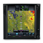
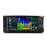
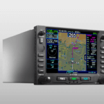
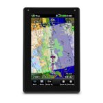
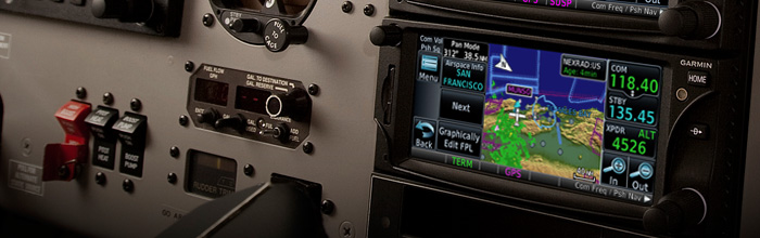
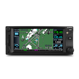
GTN 635
R109,644.85 excl. Vat
Please Note this is a discontinued product and has been replaced by the GTN 635Xi.
Out of stock
Description
Fly LPVs with GPS and Talk on VHF
- Touchscreen GPS/Comm backed by decades of proven technology
- Fly WAAS LPV approaches down to 200′ minimums
- Displays traffic, weather, terrain and more
- Interfaces with popular avionics using industry standard protocols
- Approved for installation in hundreds of aircraft models
The 2.64″ GTN 635 puts high resolution terrain mapping, graphical flight planning, multiple weather options and traffic display right at your fingertips.
Touch and Go
With its revolutionary touchscreen interface, GTN 35 puts primary functions just a few taps away. Pan across the map screen by swiping your finger across the 4.9″ high-resolution TFT display, and enter waypoint data with the onscreen alphanumeric entry. Raised grips in the bezel and a shelf across the lower edge of the display serve as gripping points in both smooth and turbulent flight conditions. Traditional concentric knobs are also available for data input. If you have a GNS 430W/530W, active flight plans automatically crossfill from the GTN to the GNS, or just manually crossfill user waypoints between devices.
Navigate with Ease
Edit your entire route using the map screen and enter new waypoints or modify existing ones, and load Victor and jet airways. A handy “rubber band” feature lets you grab any leg of your flight plan route or direct-to and move it to accommodate a deviation or ATC amendment to your flight plan. Enter your most recently visited or nearest airports as waypoints and “Direct To” destinations.
The robust 15-channel GPS receiver generates 5 position updates per second. This SBAS/WAAS-certified technology allows you to fly GPS-guided LPV glidepath instrument approaches down to as low as 200 ft. In addition, precise course deviation and roll steering outputs can be coupled to select autopilots so that IFR flight procedures may be flown automatically. This includes all ARINC 424 leg types, except RF legs. (For example, when coupled with a G500/G600 flight display, the aircraft can fly fully coupled missed approaches, including heading legs.)
Make Communication a Breeze
A fully certified, 2,280-channel VHF communications transceiver provides a standard 10 W (or optional 16 W) of power output. The system is pilot-selectable to both 25 kHz and 8.33 kHz channel spacing. Set your standby Com frequency simply by touching the onscreen number pad. Another touch of the screen switches your active and standby frequencies. Recent and favorite user frequencies also are a breeze to access. For added safety, holding down the volume knob will automatically dial in the emergency frequency.
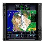
See More Than Ever Before
GTN 6d5 brings enhanced situational awareness to your cockpit. With high-resolution terrain mapping — including topography features, cities, airports, terminal areas and SUAs — and optional Class B TAWS alerting, you’ll find your way around the airspace safely and with ease. Smart Airspace™ automatically highlights airspace close to your current altitude and de-emphasizes airspace away from the current altitude. The system even allows you to load and follow Victor and jet airways. On the ground, built-in SafeTaxi® airport diagrams give you geo-referenced runways, taxiways, FBOs and hangars available in either the U.S., Europe or Canada.
Add Traffic, Weather & More
The dual-link GDL® 88 allows the GTN 635 to display up to 60 ADS-B traffic targets. TargetTrend™ relative motion technology offers pilots a faster way to judge the direction and closure rate of intruding targets in relation to their aircraft’s position. And unique SURF technology supports the display of ADS-B-equipped surface targets on SafeTaxi airport diagrams, including taxiing aircraft and ground vehicles. GDL 88 can also receive the FAA’s subscription-free FIS-B weather broadcasts that include graphical NEXRAD radar information, as well as NOTAMs, METARs and TAFs. GTN gives GDL 88 with the WAAS position source required for ADS-B, so a WAAS version of the GDL 88 is not required. Consider adding a Traffic System to compliment the GDL 88 to provide the best possible traffic coverage from now until 2020.
Couple the system with a GDL® 69 series datalink receiver to receive XM MX Satellite Weather and SiriusXM Satellite Radio (subscriptions required). An optional GSR 56 provides World Wide Weather data virtually anywhere on the globe, as well as the ability to make and receive phone calls and send and receive texts messages while in the air.
And because the GTN 635 can control the GTX™ 33 remote transponder, a GTN 635 installation could also save you valuable panel space.
Fly with Helicopter-Specific Enhancements
The GTN 635 is available with a number of optional enhancements to help meet the unique demands of helicopter missions. It’s been designed to meet the stringent helicopter vibration and temperature testing standards needed for environmental qualification. It also features a helicopter-specific obstacle database that adds nearly 30,000 low-altitude obstacles, as well as a navigation database with heliports and high-resolution terrain database. For added safety, optional HTAWS provides 5-color shading to show nearby terrain in proximity to your helicopter and provides voice callouts when descending below 500’.

Stay Up to Date
The GTN 635 features a front-loading SD™ card reader, so you can easily update your databases. PilotPak™ database bundles are now available on a single aircraft basis, saving you money and simplifying the update process. Visit flyGarmin.com to learn more.
See it in action at an upcoming seminar or with our free PC Trainer download or iPad® app.
![]()
![]()
FEATURES:
- Menu-driven graphical interface on color LCD touchscreen display
- Feature-rich MFD capabilities: moving map, airways, approaches and more
- GPS TSO’d to C146c, authorized for Class 1, 2, 3 (LPV)
- GPS WAAS-certified to Gamma-3 approach capability
- WAAS-corrected GPS signal accuracy to 1 M RMS
- Graphical flight planning (including airway navigation)
- VHF COM transceiver: 8.33 or 25 kHz channel spacing
- Com transmit power: 10 W standard, 16 W optional
- Extensive optional interface capabilities: lightning, weather, traffic and TAWS-B terrain alerting
- Integrated control/display for remote transponder
- Flight control system interface for select autopilots
- Optional XM WX Satellite Weather and SiriusXM Satellite Radio
- SafeTaxi® airport diagrams
- Award-winning product support and 2-year warranty
SPECIFICATIONS:
Physical & Performance | |
| Unit dimensions, WxHxD | 6.25″W x 2.65″H x 11.25″D (15.9 x 6.7 x 28.6 cm) |
| Display size, WxH | 4.46″W x 1.98″H (11.33 x 5.02 cm); 4.9″ diag (12.4 cm) |
| Display resolution, WxH | 600 x 266 pixels |
| Display type | Color TFT LCD; sunlight readable |
| Weight | 6.2 lbs (2.82 kg) |
| Voltage range | 11-33 |
| Built-in VHF Comm | yes |
| Transmit power | 10 watts minimum; 16 watts minimum (optional) |
| Built-in VOR/Loc/Glideslope | no |
| SBAS/WAAS receiver | 15 channel; TSO-C146c |
| IFR or VFR | IFR |
Maps, Databases & Memory | |
| Basemap | Yes |
| Navigation data | full and non-precision approaches, DPs and STARs, Victor/Jet Airways |
| Navigation database coverage areas | Americas, International or Worldwide* |
| Preloaded Terrain database | Yes |
| Preloaded Obstacle database | Yes |
| Preloaded SafeTaxi™ airport diagrams | Yes |
| Preloaded Garmin FliteCharts® | Not available |
| Jeppesen ChartView™ | No |
| Waypoints/favorites/locations | 1000 |
| Flight plans | 99 reversible; up to 100 waypoints each |
Features & Benefits | |
| Fly SBAS/WAAS approaches | Yes |
| Front-loading datacards (conveniently update database information) | Yes |
| SiriusXM™ Weather & Radio compatible | Yes |
| Traffic Information Services (TIS) alerts compatible | Yes |
| Class B TAWS alerting compatible | Yes |
| Additional | 2 year warranty Eligible for PilotPak databases*Databases included: world-wide basemap, world-wide obstacles, world-wide terrain, region-specific NavData, US SafeTaxi, US Airport Directory |
IN THE BOX:
- GTN 635 10 W COM or 16 W COM (field upgradeable)
- Cleaning cloth
- Installation kit
- Simulation software DVD
- Familiarization video DVD
- Pilot’s guide
- Cockpit reference guide
- Complimentary database update certificate
INTERFACES:
Garmin products have been designed for compatibility with a wide range of avionics. To confirm compatibility of Garmin equipment with your specific aircraft make/model and current avionics configuration, please consult your Authorized Garmin Dealer.
| Interface | Manufacturer | Model | Notes/Info |
| ADS-B Traffic Display and Control | Garmin | GDL 88 | |
| GTS 800/820/850 | |||
| Air Data Computer | B & D | 90004-003 | |
| Honeywell (Bendix/King) | KDC 281 | ||
| KDC 481 | |||
| Insight | TAS 1000 | ||
| Altitude Serializer/Encode | ACK Technologies | A-30 (Mod 8 and above) | |
| Icarus Instruments | 3000 | ||
| Sandia | SAE 5-35 | ||
| Shadin | 8800T | ||
| 9000T | |||
| 9200T | |||
| Trans-Cal Industries | IA-RS232-X | ||
| SSD120 | |||
| Audio Panel | Garmin | SL 10 | Installation of GMA 35 must include a GTN 7XX for GMA 35 control functions |
| SL 10MS | |||
| SL 10M | |||
| SL 10S | |||
| SL 15 | |||
| SL 15M | |||
| GMA 340 | |||
| GMA 347 | |||
| GMA 35 | |||
| GMA 350/350H | |||
| Honeywell (Bendix/King) | KMA 24 | ||
| KMA 24H-70/71 | |||
| KMA 26 | |||
| KMA 28 | |||
| PS Engineering | PMA 6000 | ||
| PMA 7000 Series | |||
| PMA 8000 Series | |||
| Autopilot | Bendix | M4C | |
| M4D | |||
| Century | I/II/III/IV | ||
| 21/31/42 | |||
| 2000 | |||
| Trident | |||
| AK 1081 | |||
| Cessna | 300B/400B/800B | ||
| 300 IFCS/400 IFCS/800 IFCS | |||
| Collins | APS 65 | ||
| Honeywell (Bendix/King) | KAP 100/140/150 | ||
| KFC 150/200/250/300 | |||
| KFC 225/275/325 | |||
| Sperry | SPZ 200A/500 | ||
| S-TEC | System 20/30/40/50/55/60-1/60-2/60 PSS/65 | ||
| System 55X | |||
| ST-901 | |||
| Datalink Weather Display and Control | Garmin | GDL 69/69A | GSR 56 also provides text/voice communication |
| GSR 56 | |||
| EFIS | Garmin | GDU 620 | |
| Avidyne | EXP5000 | ||
| P/N 700-00006-( ) | |||
| Honeywell (Bendix/King) | EFS 40/50 (SG 465) | ||
| EHSI | Sandel | SN 3308 | |
| SN3500/4500 | |||
| FIS-B Weather Display and Control | Garmin | GDL 88 | |
| Fuel/Air Data | Garmin | GTX 327 | |
| ARNAV | FC-10 | ||
| FT-10 | |||
| Electronics International | FP-5L | ||
| JP Instruments | EDM-700 | ||
| Shadin | F/ADC-200 | ||
| F/ADC-2000 | |||
| 91204XT(38)D (Miniflo-L) | |||
| 91053XP (Digiflo-L) | |||
| 91053XT-D (Digiflo-L) | |||
| 912802-( ) (Digidata) | |||
| IRU/AHRS | Collins | AHS-85E | |
| Lightning Detection Display and Control | L-3 Communications | WX-500 | |
| Multifunction Display | Garmin | GMX 200 | |
| MX 20 | |||
| Avidyne | EX500 (P/N 700-00007-( )) | ||
| EX5000 (P/N 700-00004-( ) or P/N 700-00030-( )) | |||
| NAV Indicator | Garmin | GI 102/A | |
| GI 106/A | |||
| Century | NSD 360A | ||
| NSD 1000 | |||
| Collins | 331A-6P | ||
| 331A-9G | |||
| PN101 (331A-3F/3G) | |||
| IND-351D | |||
| Honeywell (Bendix/King) | KI 206 | ||
| KI 208/A | |||
| KI 209/A | |||
| KI 525A | |||
| KPI 552/B | |||
| KPI 553/A/B | |||
| Mid Continent | MD222-402 | ||
| MD222-406 | |||
| MD200-302/303/306/307 | |||
| Sperry | RD 444 | ||
| RD 550A | |||
| RD 650 | |||
| S-TEC | ST 180 | ||
| TAS/TCAS/TIS Traffic Display and Control | Garmin | GTS 800/820/850 | |
| GTX 330/33/330D/33D | |||
| Avidyne (Ryan) | TAS 6XX (TCAD 9900BX) | ||
| Honeywell (Bendix/King) | KMH 880 (KMH 820) | ||
| KMH 980 (KMH 920) | |||
| KTA 870 (KTA 810) | |||
| KTA 970 (KTA 910) | |||
| L-3 Communications | SKY497 (Skywatch) | ||
| SKY899 (Skywatch HP) | |||
| Terrain Avoidance and Warning System | Honeywell (Bendix/King) | KGP 560 | |
| KMH 880 (KMH 820) | |||
| KMH 980 (KMH 920) | |||
| Transponder Display and Control | Garmin | GTX 32 | |
| GTX 327 | |||
| GTX 328 | |||
| GTX 33/33D | |||
| GTX 330/330D |