
Sub-Total: R0.00

")
")
")
")
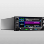
GTN 625Xi
R4,333,311.09 excl. Vat
This is an installation only product and will not be shipped. Please contact us for a free installed quote.
5 to 10 Days Delivery
Description
GPS/MFD
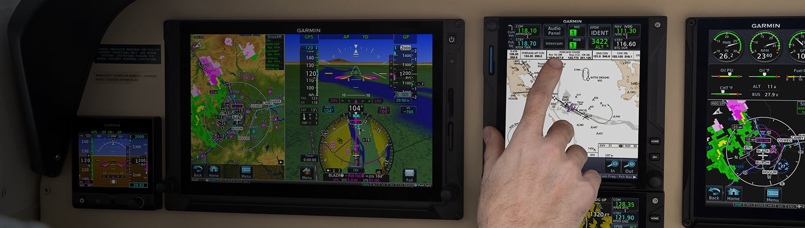
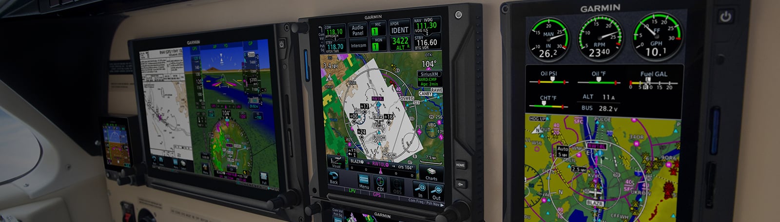
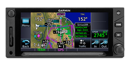
With more pixels, more processing power, more speed and performance, our GTN 625Xi system brings exciting new growth capabilities to the industry’s premier GPS/MFD platform.
![]()
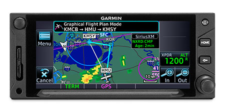
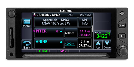
Visualize your entire flight plan, including holds and approaches on a 4.9” touch display.
![]()
Faster is better. High-speed processors cut boot-up time by 50% over earlier GTN models.
![]()
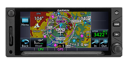
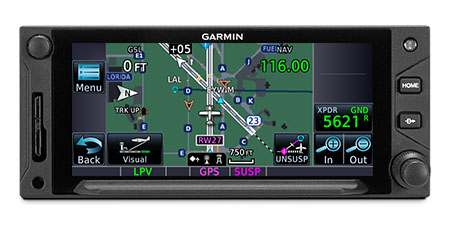
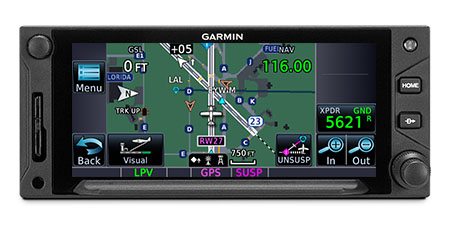
Fly the approaches you want — from visual glidepaths to LPV, RNAV and more.
![]()
It’s interface-friendly with a wide range of existing avionics, autopilots and flight displays1.
![]()
Wirelessly load flight plans and database updates with an optional Connext® link.
![]()
Upgrade? New GTN Xi series offers easy slide-in upgrade for existing GTN avionics.
Brighter, faster, sharper, better.
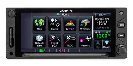
DO-IT-ALL TOUCHSCREEN
Intuitive touchscreen interface provides quick access to navigation, radio tuning, multifunction display features and more.
LIGHTNING-FAST RESPONSE
Powerful dual-core processors boost the GTN Xi series graphical display capabilities — with faster zooming, panning and map rendering on the display.
HIGH-RESOLUTION DISPLAY
With almost double the pixel count of its predecessor, the GTN Xi series features wider viewing angles and one of the highest-resolution displays ever offered in this class of avionics.
Work-saving ways to tune and display.
MULTIFUNCTION DISPLAY
Supporting multiple inputs, the 4.9” display can put moving maps, terrain, traffic2, weather2, airport diagrams and more at your fingertips.
TELL IT, TUNE IT
Available Telligence voice control technology helps reduce pilot workload by responding to hundreds of spoken commands with the press of a button on the yoke2.
EASY DATA ENTRY
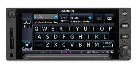
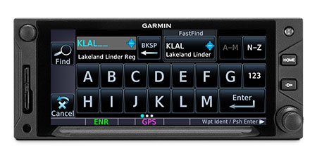
Use the on-screen QWERTY keyboard or traditional concentric knobs to enter frequencies, waypoint identifiers, routings and more.
PINCH, SWIPE GESTURES
A quick finger swipe lets you pan across the map display. Or use a smartphone-like pinch-to-zoom motion to scale up or down on any map, traffic or terrain page.

Streamline your flight planning and navigation.
SEE THE FULL PICTURE
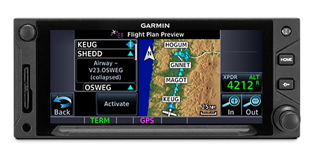
Graphical routing on the display lets you visualize your entire flight plan, including departures, arrivals, visual/instrument approaches, holding procedures and more.
FAST FIND
As soon as you start typing, the GTN Xi FastFind feature uses quick predictive logic to suggest airport and waypoint entries by using current GPS position. Just select and go.
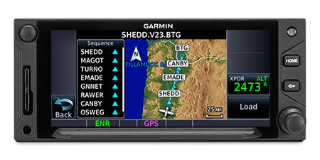
AIRWAYS, YOUR WAY
Victor airways and high-altitude jet routes can be overlaid on the map. For easy IFR routings, view airway segments available from a waypoint and corresponding exit options.
“RUBBER BAND” REROUTES
This handy feature lets you grab a flight plan leg on the screen, and then stretch or move it to adjust for a deviation or ATC amendment to your flight plan.
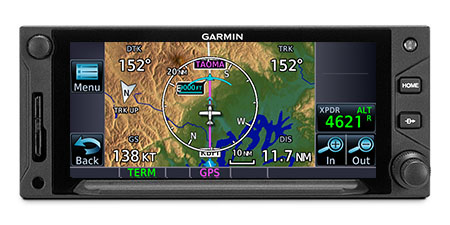
VIRTUAL MAP TOPOGRAPHY
By referencing built-in terrain, mapping and obstacles databases, GTN 625Xi shows detailed surface features, cities, airports, SUAs and more on the dynamic map display.
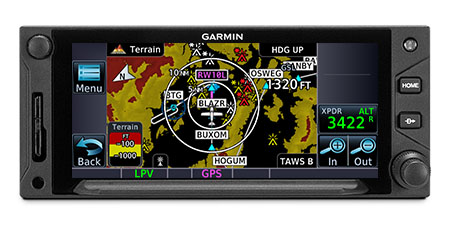
TERRAIN ALERTING
A built-in database provides color-coded display overlays to warn when potential terrain conflicts loom ahead. Class A or B TAWS alerting is optionally available.
DIRECT CONNECT
A Direct-to key on the bezel lets you quickly enter a direct course for any selected waypoint. A menu of nearest airports and flight plan waypoints makes for easy entry.

Fly approaches, glidepaths, holding patterns and more.
MORE APPROACH OPTIONS
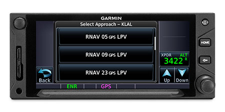
The WAAS/SBAS-certified GPS receiver expands your landing options, enabling GPS-guided LPV glidepath approaches down to ILS-comparable minimums as low as 200’.
![]()
CLEARED FOR THE VISUAL
GTN Xi can give advisory visual approach guidance based on a published glidepath or a 3-degree slope from the runway threshold (with terrain/obstacle clearance).
AUTOPILOT INTERFACE
Precise course deviation and roll steering outputs can be coupled to select autopilots, enabling virtually all IFR flight procedures to be flown automatically.
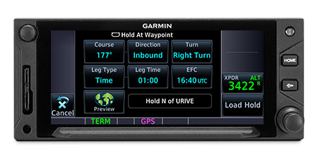
HOLDING PATTERNS
IFR pattern entries can be tricky. GTN 625Xi lets you easily create and execute holding patterns over a published or user-defined waypoint.
SEARCH AND RESCUE
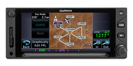
For aerial surveillance, common search pattern types — including orbit, parallel line, expanding square and sector search — can be loaded into your flight plan on the GTN 625Xi navigator2.
SAFETAXI DATABASE
Upon landing, georeferenced SafeTaxi diagrams on the display automatically help track your location on hundreds of airports.
Add ADS-B traffic, weather and more.
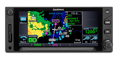
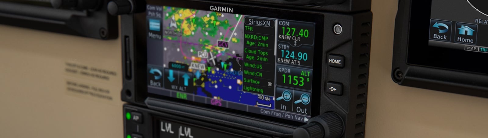
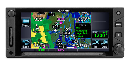
ADS-B DATA LINKS
With available Garmin ADS-B “In” equipage solutions, GTN 625Xi can display up to 60 ADS-B traffic targets as well as subscription-free U.S. weather data.
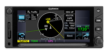
TARGETTREND TRACKING
ADS-B based TargetTrend relative motion tracking on the GTN Xi display gives pilots a faster, more intuitive way of judging traffic closure rates and trajectories.
TERMINALTRAFFIC DISPLAY
Providing a dynamic display of ADS-B-equipped aircraft and ground vehicles, this technology helps pilots avoid traffic conflicts within the airport environment.
ACTIVE TRAFFIC SOLUTIONS
For more advanced traffic surveillance capability, GTN Xi can integrate with select TAS or TCAS/ACAS systems, including our GTS family of ADS-B enhanced products.
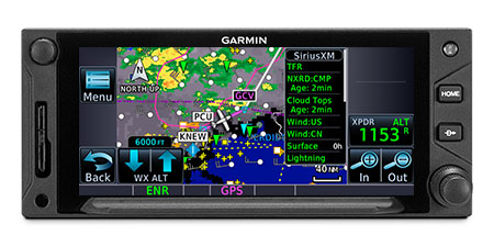
SIRIUSXM® SERVICE
When paired with an optional GDL 69 datalink receiver, GTN Xi can incorporate SiriusXM satellite weather coverage — plus audio entertainment features4.
WORLDWIDE COMMUNICATIONS
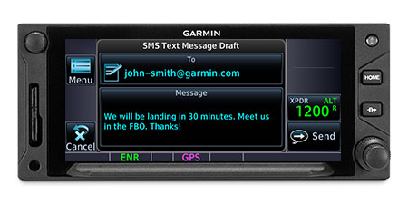
Want global weather, radar imagery and two-way text/voice communications from the air? Connect your GTN 625Xi with our optional GSR 56 satellite link4.

Wirelessly connect your electronic flight bag.
CONNECTED COCKPIT
Use optional Connext technology to stream information between GTN Xi and compatible Garmin portables or mobile devices running the Garmin Pilot or FltPlan Go apps5.
FLIGHT PLAN TRANSFER
Save time by creating your flight plan on your mobile device at home, then use Connext2 to wirelessly upload the data into your GTN Xi during preflight at the airport.
FLIGHT STREAM
In addition to GPS data, a compatible Connext wireless gateway5 can stream ADS-B traffic, weather and backup attitude data to your mobile device in real time2.
DATABASE SYNC
A Flight Stream 510 Connext gateway5 adds Database Concierge to your GTN Xi navigator. Upload databases from your tablet in minutes — then let automatic sync with your avionics do the rest.
1 Reference the supported interfaces for compatibility details
2 Optional feature; additional hardware may be required
3 Jeppesen subscription required for use with optional Garmin ChartView (sold separately)
4 Sold separately; subscription plan(s) required
5 Sold separately
6 Requires optional enablement
Sirius, XM and all related marks and logos are trademarks of Sirius XM Radio Inc. Jeppesen is a registered trademark of Jeppesen Sanderson, Inc. its subsidiaries or affiliated companies.
SPECS
- TSO applicability: C74d Class A; C112e; C146e Class 3; C151d Class A, B; C157b Class 1, 2; 165b; C194; C195b Class B1, B3, B5, B7; C209
- Display size: 4.9″ (125 mm) diagonal
- Display resolution: 834 pixels (W) x 370 pixels (H)
- Unit bezel height: 2.65″ (67 mm)
- Unit bezel width: 6.25″ (159 mm)
- Unit depth with connectors: 11.25″ (286 mm) (measured from face of aircraft panel to rear of connector backshells)
- Unit weight: 4.1 lbs (1.88 kg)
- Input voltage range: 11 VDC – 33 VDC
- Operating temperature range: -20° C to 55° C (-4° F to 131° F)
- Number of GPS channels: 15 (12 GPS and 3 GPS/WAAS/SBAS)
- LAT/LON position accuracy: <1.25 meter RMS horizontal, < 2 meter vertical, with WAAS
- Maximum velocity: 1,166 knots
- Position update Interval: 0.2 sec (5 Hz)
INTERFACES
Garmin products have been designed for compatibility with a wide range of avionics. To confirm compatibility of Garmin equipment with your specific aircraft make/model and current avionics configuration, please consult your Authorized Garmin Dealer.
| Interface | Manufacturer | Model | Notes/Info |
| Air Data Computer | B & D | 90004-003 | |
| Honeywell (Bendix/King) | KDC 281 KDC 481 | ||
| Insight | TAS 1000 | ||
| Altitude Serializer/Encoder | Garmin | GTX 327 | |
| ACK Technologies | A-30 (Mod 8 and above) | ||
| ARNAV | FC-10 FT-10 | ||
| Electronics International | FP-5L | ||
| Icarus Instruments | 3000 | ||
| JP Instruments | EDM-700 | ||
| Sandia | SAE 5-35 | ||
| Shadin | 833811-00 (AIS-380) 8800T F/ADC-200 F/ADC-2000 91204XT(38)D (Miniflo-L) 91053XP (Digiflo-L) 91053XT-D (Digiflo-L) 912802-( ) (Digidata) | ||
| Trans-Cal Industries | IA-RS232-X SSD120 | ||
| Audio Panel | Garmin | SL10 SL10MS SL10M SL10S SL15 SL15M GMA 340 GMA 347 GMA 35(c) GMA 350(c)/350H(c) | |
| Honeywell (Bendix/King) | KMA 24 KMA 24H-70/71 KMA 26 KMA 28 | ||
| PS Engineering | PMA 6000 PMA 7000 Series PMA 8000 Series | ||
| Autopilot | Garmin | GFC 500 GFC 600 | |
| Bendix | M4C M4D | ||
| Century | I/II/III/IV 21/31/41 2000 Trident AK 1081 | ||
| Cessna | 300B/400B/800B 300 IFCS/400 IFCS/800 IFCS/1000 IFCS | ||
| Collins | APS 65 ( ) | ||
| Honeywell (Bendix/King) | KAP 100/140/150 KFC 150/200/250/300 KFC 225/275/325 | ||
| Sperry | SPZ 200A/500 | ||
| S-TEC | System 20/30/40/50/55/60-1/60-2/60 PSS/65 System 55X ST-901 | ||
| Datalink Weather Display and Control | Garmin | GDL 69/69A GSR 56 | GDL 69A also provides SiriusXM radio entertainment. GSR 56 also provides text/voice communication |
| DME Control | Collins | DME 40 DME 42 | |
| Honeywell (Bendix/King) | KN62/62A KN63 KN64 KDI 572/574 KDM 706 | ||
| Narco | DME 890 IDME 891 | ||
| EFIS | Garmin | G500/G600 TXi Series G5 G3X Touch | |
| Avidyne | EXP5000 | ||
| Honeywell (Bendix/King) | EFS 40/50 (SG 465) | ||
| EHSI | Sandel | SN 3308 SN3500/4500 | |
| FIS-B Weather Display and Control | Garmin | GDL 88 | |
| Fuel/Air Data | Garmin | GTX 327 | |
| ARNAV | FC-10 FT-10 | ||
| Electronics International | FP-5L | ||
| JP Instruments | EDM-700 | ||
| Shadin | F/ADC-200 F/ADC-2000 91204XT(38)D (Miniflo-L) 91053XP (Digiflo-L) 91053XT-D (Digiflo-L) 912802-( ) (Digidata) | ||
| IRU/AHRS | Collins | AHS-85E | |
| Lightning Detection Display and Control | L-3 Communications | WX-500 | |
| Multifunction Display | Garmin | GMX 200 MX20 | |
| Avidyne | EX500 EX5000 | ||
| NAV Indicator | Garmin | GI 102/A GI 106/A | |
| Century | NSD 360A NSD 1000 | ||
| Collins | 331A-6P 331A-9G PN101 (331A-3F/3G) IND-351D | ||
| Honeywell (Bendix/King) | KI 202A/203/204/206 KI 208/A KI 209/A KI 525A KPI 552/B KPI 553/A/B | ||
| Mid Continent | MD222-402 MD222-406 MD200-302/303/306/307 | ||
| Sperry | RD 444 RD 550A RD 650 | ||
| S-TEC | ST 180 | ||
| Synchro Heading Source | Bendix/King | KI-525A | |
| TAS/TCAS/TIS Traffic Display and Control | Garmin | GTS 800/820/850 GTX 330/33/330D/33D | |
| Avidyne (Ryan) | TAS 6XX (TCAD 9900BX) | ||
| Honeywell (Bendix/King) | KMH 880 (KMH 820) KMH 980 (KMH 920) KTA 870 (KTA 810) KTA 970 (KTA 910) | ||
| L-3 Communications | SKY497 (Skywatch) SKY899 (Skywatch HP) | ||
| Terrain Avoidance and Warning System | Honeywell (Bendix/King) | KGP 560 KMH 880 (KMH 820) KMH 980 (KMH 920) | |
| Transponder Display and Control | Garmin | GTX 32 GTX 327 GTX 328 GTX 33/33D GTX 330/330DGTX 325/335(R)/345(R) | |
| Weather Radar Display and Control | Garmin | GWX 68 GWX 70GWX 75 | |
| Bendix/King | RDS 81 (RS 811A) RDS 82 (RS 181A) RDR 2000 (ART 2000) RDR 2100 (ART 2100) |
Additional information
| Weight | 4.1 lbs |
|---|---|
| Dimensions | 11.25 × 6.25 × 2.65 in |

Reviews
There are no reviews yet.